NASA’s Mars Perseverance rover has verified lake sediments at the base of the Jezero crater, confirming the presence of an ancient lake on Mars, and reinforcing hope that traces of life may exist on the Red Planet, according to a study.
The research, published in the journal Science Advances, shows that at some point, the crater filled with water, depositing layers of sediments on the crater floor.
The lake subsequently shrank and sediments carried by the river that fed it formed an enormous delta. As the lake dissipated over time, the sediments in the crater were eroded, forming the geologic features visible on the surface today.
The periods of deposition and erosion took place over aeons of environmental changes, the radar indicates, confirming that inferences about the Jezero crater’s geologic history based on Mars images obtained from space are accurate.
“From orbit we can see a bunch of different deposits, but we can’t tell for sure if what we’re seeing is their original state, or if we’re seeing the conclusion of a long geological story,” said David Paige, professor of Earth, planetary and space sciences at University of California-Los Angeles.
“To tell how these things formed, we need to see below the surface,” Paige said.
The rover, which is about the size of a car and carries seven scientific instruments, has been exploring the 30-mile-wide crater, studying its geology and atmosphere and collecting samples since 2021. Perseverance’s soil and rock samples will be brought back to Earth by a future expedition and studied for evidence of past life.
Between May and December 2022, Perseverance drove from the crater floor onto the delta, a vast expanse of 3 billion-year-old sediments that, from orbit, resembles the river deltas on Earth.
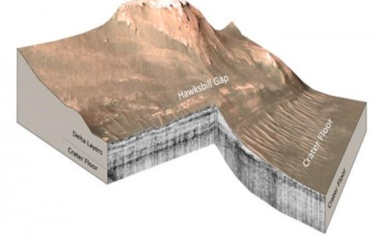
As the rover drove onto the delta, Perseverance’s Radar Imager for Mars’ Subsurface Experiment (RIMFAX) instrument fired radar waves downward at 10-centimetre intervals and measured pulses reflected from depths of about 20 metres below the surface.
With the radar, scientists can see down to the base of the sediments to reveal the top surface of the buried crater floor.
Years of research with ground-penetrating radar and testing of RIMFAX on Earth have taught scientists how to read the structure and composition of subsurface layers from their radar reflections. The resulting subsurface image shows rock layers that can be interpreted like a highway road cut.
RIMFAX imaging revealed two distinct periods of sediment deposition sandwiched between two periods of erosion. The researchers reported that the crater floor below the delta is not uniformly flat, suggesting that a period of erosion occurred prior to the deposition of lake sediments.
The radar images show that the sediments are regular and horizontal — just like sediments deposited in lakes on Earth. The existence of lake sediments had been suspected in previous studies, but has been confirmed by this research.
A second period of deposition occurred when fluctuations in the lake level allowed the river to deposit a broad delta that once extended far out into the lake, but has now eroded back closer to the river’s mouth.

